Tutorial 15
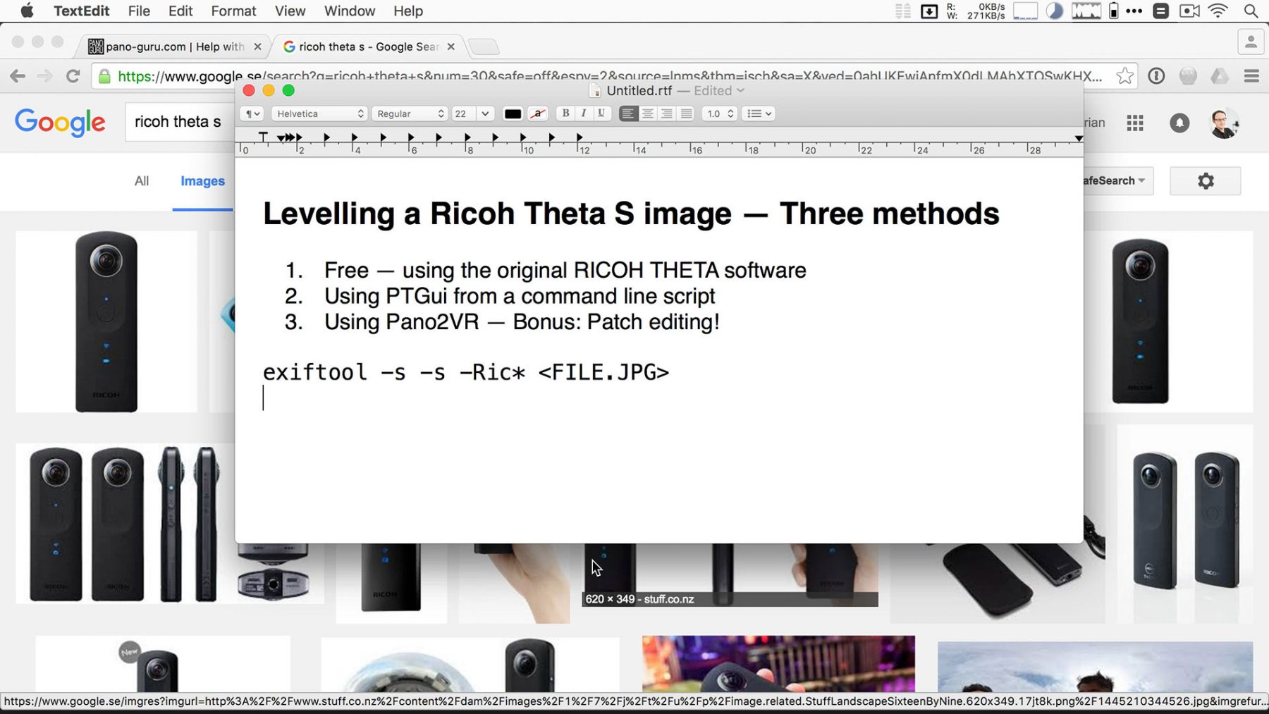
In this this tutorial I demonstrate just three of the many possible ways of levelling your Ricoh Theta panoramas — a question that seems to come up quite frequently.
Those three methods are
- The original RICOH THETA software (free)
- Using PTGui from a command line script
- Using Pano2VR — Bonus: Patch editing!
Links: My command line script, and the fabulous Exiftool.
This is Part 15 in a whole series of tutorials!
Hi Florian,
how do you preserve the Exif Data after patching and converting in Pano2VR?
Basic question, I am shooting a 4 shot panorama with a 8mm fisheye on a tripod with rotator head. I take 1 shot at 0 degree position, then 90, then 180 and the forth at the 270 degree position. Next I need to take the up and down shots.. Question, do I rotate the camera back to the 0 position and then take the up down or do I leave the camera at the 270 deg. position and shoot the up / down shots there. I have seen tutorials that do it both ways.. does it make a difference. I use both PTGui and Panoweaver.. is the position software dependent?
Makes absolutely no difference. However, I would recommend you pick one and then stick to it as your own convention, because one day you might just have trouble bringing that zenith shot in on a featureless sky – then it helps knowing roughly what yaw it was shot at (0 or 270 ;-))
Hi!
I’m a bit lost here, I’m trying to execute your script but nothing happens, if I execute: “exiftool -All” to show all tags in the image from my Theta S there’s no info about Roll…???
Here’s the info I get:
ExifTool Version Number : 10.25
File Name : R0010207.jpg
Directory : /Users/roleks/Desktop/test
File Size : 2.8 MB
File Modification Date/Time : 2016:09:04 17:14:54+02:00
File Access Date/Time : 2016:09:04 18:14:40+02:00
File Inode Change Date/Time : 2016:09:04 17:14:54+02:00
File Permissions : rw-r–r–
File Type : JPEG
File Type Extension : jpg
MIME Type : image/jpeg
JFIF Version : 1.01
Exif Byte Order : Big-endian (Motorola, MM)
Image Description :
Make : RICOH
Camera Model Name : RICOH THETA S
Orientation : Horizontal (normal)
X Resolution : 72
Y Resolution : 72
Resolution Unit : inches
Software : Photos 1.5
Modify Date : 2016:09:04 14:20:40
Copyright :
Exposure Time : 1/6400
F Number : 2.0
Exposure Program : Program AE
ISO : 100
Sensitivity Type : Standard Output Sensitivity
Exif Version : 0230
Date/Time Original : 2016:09:04 14:20:40
Create Date : 2016:09:04 14:20:40
Components Configuration : Y, Cb, Cr, –
Compressed Bits Per Pixel : 3.2
Aperture Value : 2.0
Brightness Value : 9.6
Exposure Compensation : 0
Max Aperture Value : 2.0
Metering Mode : Multi-segment
Light Source : Unknown
Flash : No Flash
Focal Length : 1.3 mm
Flashpix Version : 0100
Color Space : sRGB
Exif Image Width : 5376
Exif Image Height : 2688
Exposure Mode : Auto
White Balance : Auto
Scene Capture Type : Standard
Sharpness : Normal
GPS Version ID : 2.3.0.0
GPS Latitude Ref : North
GPS Longitude Ref : East
GPS Altitude Ref : Above Sea Level
GPS Time Stamp : 12:20:40
GPS Img Direction Ref : True North
GPS Img Direction : 247.5
GPS Map Datum : WGS84
GPS Date Stamp : 2016:09:04
XMP Toolkit : XMP Core 5.4.0
Creator Tool : Photos 1.5
Date Created : 2016:09:04 14:20:40
Description :
Rights :
Current IPTC Digest : 15f253fb699e2c71d4fdd42105ed4d36
Coded Character Set : UTF8
Application Record Version : 2
Copyright Notice :
Caption-Abstract :
IPTC Digest : 15f253fb699e2c71d4fdd42105ed4d36
Image Width : 5376
Image Height : 2688
Encoding Process : Baseline DCT, Huffman coding
Bits Per Sample : 8
Color Components : 3
Y Cb Cr Sub Sampling : YCbCr4:2:0 (2 2)
Aperture : 2.0
GPS Altitude : 2 m Above Sea Level
GPS Date/Time : 2016:09:04 12:20:40Z
GPS Latitude : 59 deg 24′ 20.40″ N
GPS Longitude : 18 deg 21′ 3.63″ E
GPS Position : 59 deg 24′ 20.40″ N, 18 deg 21′ 3.63″ E
Image Size : 5376×2688
Megapixels : 14.5
Shutter Speed : 1/6400
Focal Length : 1.3 mm
Light Value : 14.6
I have a licensed version of PTGui Pro.
Thanks for all the tutorials, it’s been really helpful! 🙂
Hm, that’s strange. How did you get the file? Did you directly transfer it off the Theta with OSX’s Image Capture.app?
Yes, with the OS X Image Capture app directly.
It seems like the pitch information no longer exists in the EXIF, maybe Ricoh has changed it? I’m running the latest firmware and software from Ricoh.
RolandMijersMBP:~ roleks$ level_theta_image.sh /Users/roleks/Desktop/test/R0010208.jpg
Version 0.3 | 11 May 2016 | Florian Knorn | pano.ie
Creating PTGui Project File…
Error, missing Pitch information in EXIF!
RolandMijersMBP:~ roleks$
Hm, that is indeed strange. Either way, if the pitch / roll data is missing, then the script simply can’t do its work…
Sorry for my ignorance, I was using the Photos app and not the Image Capture App. Now everything works fine 🙂
The Photos app strips out the Pitch and Roll EXIF when importing from the device…
Thanks again for all your tutorials 🙂
Hi Florian
Thanks for the video!
Do you know how i can get multiple images from ricoh all centered at north using the exif compass data?
I don’t have anything prepared, but it should be straightforward to hack something together based on exiftool (for reading out the appropriate EXIF field) and then Imagemagick’s convert (in order wrap/offset the image appropriately)…
Hi Florian, hi guys,
any of you have ever tried the classic nadir patching method with the Ricoh Theta? I mean the method of taking a first shot and then a second from a nearby position pointing to 45 degrees below horizontal and then taking the second shot what need to recover the ground or floor doing the processing in Ptgui. Like you do in the first tutorial. I think it should work. What do you think? Tks best, Valerio
Well it’s easier to patch in a small patch. If you take a whole 360 equi just for patching it’s a) overkill, and b) much more difficult to “fit in”… But given the small nadir area, it’s just retouch it rather than try to map in some pixels from a separate image.
Just found this thread. I’m having troubles with setting control points. I’ll admit, I’m brand new to 360s and the like. I took a series of pictures with my ThetaS, but the stand setup was slightly off vertical, and all the pics are wonky. I can open the panoramic, but the setting of control points, in the video is hard for me to follow.
Well, you can also just use the Ricoh Software for levelling, that should be much more straightforward 😉
Thanks Florian for the piece of info. I was courious on your warning about the better image quality obtained via USB cable direct form the camera rather than wirelessly by smartphone and checked it out with a significant difference on the weight of the file (2.3 Mb UDB Vs. 868 K by Wi-fi ) but not on the resolution (level of noise or detail pixelation) at first sight by zooming the image on the screen. I expected to notice it but shockingly I didn´t.
PS: I tested only the flat format, perhaps quality differences would be appreciable when orbiting?.
Thanks in advance.